Product 1.7
 Satellite Water Coastal Monitoring
Executive Summary
Estimation of sea surface temperature (SST) and Chlorophyll-a (CHL-a) concentration was carried out using thermal infrared data from the Sentinel-3 mission and multispectral data from the Sentinel-2 mission, respectively. Supervised machine learning, including both batch and online learning, was adopted to estimate both sea parameters, with in-situ measurements used as ground truth information. The Random Forest (RF) algorithm was used for batch learning, whereas both Mondrian Forest (MF) and Hoeffding Forest (HF) were used for online learning. For each method, accuracy indices were computed for a performance evaluation. In addition, a pointwise uncertainty map was produced for each estimated map. The results showed promising performance across all methods.
Description of Datasets
The first dataset consists of Sentinel-3 Sea and Land Surface Temperature Radiometer (SLSTR) Level-1B radiance brightness temperature products, which provide calibrated radiance measurements in the thermal infrared domain. Specifically, three SLSTR thermal infrared bands (S7, S8, and S9) are utilized. The considered area includes the Ligurian Sea and part of the Western Mediterranean sea. For each in situ sea truth temperature measurement acquired in the Ligurian sea, a corresponding feature vector is constructed using radiance brightness temperature values from these three bands at matching spatial and temporal coordinates. The resulting dataset is used for supervised machine learning–based estimation of SST, where in situ temperature observations serve as ground truth, and SLSTR-derived spectral features form the input predictors.
The second dataset consists of Sentinel-2 Level-2A surface reflectance products, derived from atmospherically corrected multispectral imagery. It utilizes spectral information from twelve bands spanning the visible, near-infrared (NIR), and shortwave-infrared (SWIR) regions. Images, in this case, are related to two different areas, one including the sea in front of the Mount of Portofino, while the other is related to the La Spezia Gulf. For each in situ measurement of CHL-a concentration, a corresponding feature vector is extracted, containing reflectance values from the twelve Sentinel-2 bands at the same spatial location and acquisition time. These spectral bands are particularly sensitive to optical properties of water bodies, such as pigment absorption and scattering effects associated with algal biomass. The resulting dataset is designed for supervised machine learning–based estimation of CHL-a concentration, where in situ CHL-a measurements are used as ground truth, and Sentinel-2 spectral features serve as predictor variables.
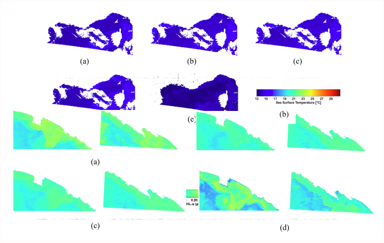
Description of Results
All machine learning methods (RF, MF, and HF) trained on the datasets described in Section 2 were applied to the complete Sentinel-3 and Sentinel-2 acquisitions over the Ligurian Sea, Italy. An example of the estimated SST maps at 1 km spatial resolution, for February 13, 2023, is shown in Figure 1, while an example of the estimated CHL-a concentration maps at 60 m spatial resolution, for March 23, 2018, is presented in Figure 2. Cloud-covered and land areas are masked in white.
The contribution of ENEA and DISTAV is acknowledged, for sea truth data procurement and for discussion about experiment design and obtained results.