Project 11
 Development of innovative Technologically Assisted Citizen Science Systems (TACS)
Citizen Science is increasingly recognised as a powerful driver of ecological research, enabling non-professionals to contribute high-quality data across wide spatial and temporal scales. In the marine domain in particular, Marine Citizen Science Initiatives have expanded rapidly since the 1980s, peaking in the early 2010s, and now encompass biodiversity monitoring, pollution tracking, fisheries observation, ecosystem change detection, and cross-disciplinary themes spanning physics, biogeochemistry and biology. Mapping activities have identified hundreds of initiatives worldwide, with Europe and North America as major hubs and a growing presence in developing regions.
Supported by photography, low-cost sensors, mobile applications and oceanographic instruments, these projects engage divers, sailors, fishers, students and coastal communities, often applying validation, calibration and standardised protocols to ensure data quality, although transparency in quality procedures remains uneven.
At the same time, advances in eco-robotics have opened new possibilities for environmental stewardship. Eco-robots – equipped with sensors, cameras and artificial intelligence – can operate in remote or hazardous environments, collecting high-resolution data on water quality, pollution and ecosystem health while adhering to sustainable design principles. The integration of citizen science and eco-robotics creates a powerful model of environmental innovation: community members can deploy robotic platforms, contribute to data interpretation, and support the development of accessible monitoring tools.
Technological analyses highlight a complementary landscape. High-end, reference-grade systems achieve strong compliance with FAIR principles (Findability, Accessibility, Interoperability and Reusability) and provide calibration benchmarks, while emerging citizen-driven technologies – such as low-cost sensors, drifting buoys, micro-AUVs and eDNA samplers – offer scalability and broaden geographical coverage.
Initiatives such as those promoted through RAISE SPOKE 3 exemplify this synergy, combining community engagement with advanced robotic technologies to address local environmental challenges. Together, citizen participation and eco-robotics democratise science, strengthen environmental awareness, and support scientifically rigorous, socially inclusive and ecologically sustainable monitoring.
The Project 11 examines a wide portfolio of environmental sensing technologies (e.g., OpenCTD, EnvLogger, MeteoTracker, eDNA samplers) and digital tools (e.g., AlgaWarning, CESP).
Learn more about the digital environmental monitoring technologies and digital tools and the TACS partner projects.
NAVIGATE DATA
- AlgaWarning
- EnvLogger
- MeteoTracker
- OpenCTD
- The Custodian Earth Solution Platform (CESP)
- eDNA
- TACS partner projects
AlgaWarning is a Citizen-enabled platform for monitoring harmful algal blooms (HABs).
HABs, rapid proliferations of microscopic phytoplankton, pose global threats to coastal ecosystems, public health, and marine economies. These blooms can release toxins that kill marine life, contaminate seafood, and cause human illness, making timely detection and management crucial. The IOC Harmful Algal Bloom Programme supports nations in understanding, predicting, and mitigating HABs through improved monitoring and management.
Within this context, the AlgaWarning project, developed by ETT SpA with partners including the Department of Experimental Medicine of the University of Genoa (UNIGE-DIMES) and the Liguria Environmental Protection Agency (ARPAL), provides a participatory platform for real-time HAB monitoring and data sharing. It enables scientists, agencies, and volunteers to collect, analyse, and share microalgae observations efficiently. Field operations are based on the integration of several tools: a portable system equipped with DIPLE® lenses and LED illumination, a slide stage, and a Sedgewick-Rafter counting chamber, enabling high-resolution on-site phytoplankton analysis.
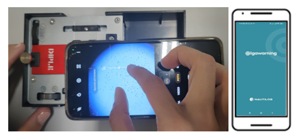
The system is complemented by a dedicated mobile application capable of capturing micrometric, geolocated images of the microalgae present in the marine sample and automatically transmitting them to a centralized platform for further processing and in-depth analysis.
The platform guides users through sample processing, cell counting, preliminary species identification, and metadata annotation – including time, location (WGS84), and ISO 8061-compliant data – ensuring GIS interoperability. While expert supervision currently validates species identification, AI-based classification tools are in development to automate and accelerate analysis, enhancing scalability and near real-time risk assessment.
Standard regional monitoring by ARPAL along the Ligurian coast complements the platform with biweekly summer sampling conducted at 16 sites, recording species such as Ostreopsis ovata and Prorocentrum Lima in concentrations exceeding tens of millions of cells per litre.
The adoption of AlgaWarning within ARPAL’s routine monitoring framework provides several operational advantages:
- Faster on-site detection and preliminary identification of harmful microalgal species, reducing response time during bloom events;
- High-resolution, smartphone-assisted microscopy directly in the field, minimizing delays associated with laboratory processing;
- Immediate geolocated image acquisition and real-time data upload to a centralized platform, improving data traceability and coordination;
- Enhanced collaboration between agencies and citizen scientists, strengthening early warning capacity and environmental surveillance.
EnvLogger is a compact, robust temperature logging system paired with a dedicated smartphone application. It is designed to be reliable, easy to use, and suitable for a wide range of environmental conditions. Data transfer is enabled via NFC, allowing quick, touchless communication with a smartphone.
Key features include:
- Durability: resistant to UV, dirt, humidity, water, and impacts, suitable for harsh field conditions;
- Rapid deployment: loggers can be configured in seconds, with memory retaining previous settings for sequential programming;
- Automated logging: supports “automatic mode” on Android, ideal for inaccessible or underwater locations;
- Immediate data storage: data are displayed in the app and saved instantly in a standardized and exportable CSV format for easy import into Excel, R, or MATLAB;
- Non-volatile memory: ensures data remain accessible even if the battery is depleted;
- Flexible scheduling: missions can start immediately or be delayed; timestamps and time zones are fully supported;
- Background logging: all operations are recorded in a background log file for review or troubleshooting.
EnvLogger supports both mobile and fixed-position deployments. In diving applications, sensors worn by scuba divers provide repeated measurements at fixed locations, generating high-value time series data that complement official climatology. Comparison with Copernicus Marine Service climatology enables identification of anomalies.
Fixed-position deployments can be used to monitor urban heat. Notably, sensors were installed in Porto Antico di Genova in exposed locations, including on heat-absorbing metallic surfaces, recorded pronounced temperature peaks during summer, providing insight into local microclimates and heat-wave effects in public spaces.
EnvLogger thus offers versatile, high-resolution temperature monitoring for coastal, urban, and underwater environments, supporting both research and citizen-science applications.
The MeteoTracker (MT) is a patented, low-cost mobile meteorological station designed for collecting high-resolution atmospheric data while in motion. Central to its design is the RECS (Radiation Error Correction System), a dual-sensor differential system that corrects temperature errors caused by solar radiation and vehicle speed variations, ensuring accurate measurements in diverse conditions.
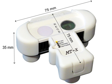
MT directly measures temperature, relative humidity, and pressure, and derives additional parameters including thermal gradient, dew point, heat index, solar intensity, potential temperature, altitude, and vehicle speed. Sensors include the TMP117 for temperature, HDC3022 for humidity, and Bosch BMP390 for pressure. The compact device (75 × 75 × 35 mm) has a battery life of 10-18 weeks, extendable with an optional solar panel.
MT is typically mounted on vehicles, bicycles, or carried by hand, transmitting geolocated data via a smartphone app. This enables continuous measurement along routes, producing detailed thermal maps of urban, rural, and natural environments.The data are then transmitted to a smartphone application where they are geolocated using GPS. Once uploaded to the platform, the measurements are processed and visualized as detailed maps showing temperature variations across space.
Key applications include:
- Microclimate identification: detecting small-scale temperature variations within short distances;
- Urban heat island analysis: highlighting warmer urban centres and cooler shaded or vegetated areas;
- Environmental monitoring: tracking seasonal changes and the impact of weather events;
- Educational and citizen science use: teaching atmospheric science and climate observation.
Repeated measurements along fixed routes allow robust analysis of spatial variability, distinguishing transient weather fluctuations from persistent microclimatic patterns. Combining temperature with atmospheric pressure and humidity data provides insight into broader meteorological conditions and thermal comfort. Derived indices such as Humidex and the Discomfort Index quantify perceived heat and human heat stress.
Overall, MeteoTracker offers high spatial resolution, temporal comparability, microclimate detection, and assessment of thermal comfort, providing a dynamic complement to traditional fixed weather stations.
A CTD (Conductivity, Temperature and Depth) is one of the most fundamental instruments in the oceanographer’s toolkit. It consists of a set of sensors that collect measurements, which are processed by a control unit to calculate additional parameters. The CTD’s control unit often includes additional functionalities, such as wireless communication with a surface vessel, GPS position logging, and onboard data storage. Variations in salinity, temperature, and depth are key parameters used to distinguish different water masses, providing crucial information about the structure and dynamics of marine environments.
Globally, extensive datasets from CTD measurements exist, collected from lakes, seas, and oceans. These historical and ongoing measurements are invaluable for monitoring long-term changes in climate, ocean conditions, and water column properties.
CTDs can be deployed in several ways depending on research objectives. They can be lowered or raised along a water column to obtain a vertical profile, providing a detailed snapshot of changes across water layers. Alternatively, CTDs can be installed in fixed positions to monitor temporal variations at a single site, or towed horizontally to detect spatial anomalies across broader areas.
Measurements obtained with a CDT/OpenCTD can be combined to obtain additional information on sea conditions:
- Conductivity, temperature and pressure can be combined to calculate salinity;
- Pressure and temperature are used to derive depth;
- Temperature, salinity and depth can be used to calculate the speed of sound in water.
The OpenCTD is an open‑source, low‑cost oceanographic instrument designed for budget-restricted scientists, educators, and researchers working in nearshore coastal ecosystems. It was developed by a core team of marine ecologists and engineers working under the initiative Oceanography for Everyone with input from a wider distributed community of researchers, makers and conservation practitioners.
The Custodians Earth Solution Platform (CESP), developed by the BioDesign Foundation with ETT S.p.A., is a digital tool that empowers citizens, organisations, and institutions to document and address environmental problems. By connecting those who encounter ecological issues with those able to act, CESP frames environmental stewardship as a collective societal responsibility
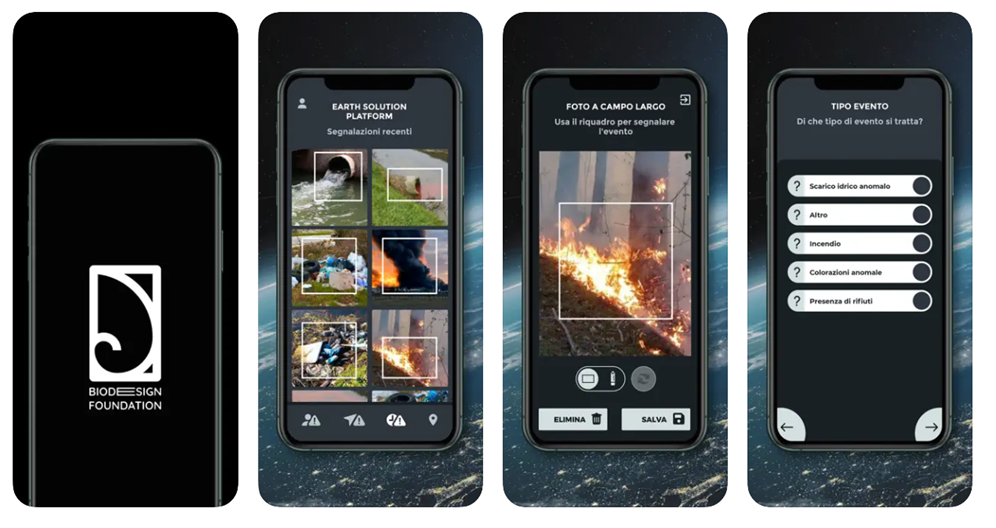
Accessible via The Custodians App on Android and iOS, the platform allows users to report geo-referenced environmental issues – such as microplastics, oil spills, discarded nets, or hazardous materials – through photos and brief descriptions. These “challenge points” are mapped publicly, and their status updates from “challenge” to “solution” as remediation occurs (e.g. whether cleanup, remediation, or reporting to authorities), providing real-time data to environmental managers, NGOs, authorities, and emergency teams.
CESP has been central to The Custodians Plastic Race, a high-profile initiative launched during The Ocean Race 2023 Grand Finale in Genoa, mobilising volunteers and institutions to clean plastic and waste across urban and coastal areas. The app coordinated teams across nine municipal districts, prioritising areas and tracking progress. This model has since been replicated in other events, including the Marina Militare Nastro Rosa Tour, Foiling Week, EUROSAF sailing events, and the European Athletics Championships in Rome, engaging schools, NGOs, military, coast guard, and corporate volunteers.
By translating citizen observations into actionable environmental intelligence, CESP facilitates large-scale, coordinated action and provides a real-time map of environmental challenges and interventions. Its growing adoption and visibility demonstrate its effectiveness as a citizen-science platform for environmental stewardship.
Environmental DNA (eDNA) is genetic material shed by organisms into their surroundings, such as water, soil, or air. In marine environments, it originates from scales, mucus, gametes, or faeces, providing a snapshot of species present without the need for visual observation or capture. eDNA offers rapid, sensitive, and cost-effective tools for assessing biodiversity, detecting invasive species, and monitoring elusive organisms
Citizen science greatly expands eDNA monitoring, engaging volunteers, sailors, schools, and coastal communities to collect water samples over large areas and extended periods. By following standardised protocols, participants generate high-quality data that feed into regional and national biodiversity databases, supporting research, conservation, and policy.
To enable broad participation, low-cost pumps and filter systems have emerged as essential tools for eDNA sampling. These systems typically include a small, battery-powered pump that draws water through a fine filter, capturing cellular material and DNA fragments, which can then be preserved for laboratory analysis. Standard operating procedures, including sample handling, sterilisation, and metadata recording, ensure data reliability. GPS-linked sampling allows precise mapping of species distributions and environmental gradients.
The use of low-cost pumps and filters in citizen science programs allows participants to collect reproducible samples with minimal training. The approach is scalable and adaptive, allowing rapid mobilisation of volunteers to emerging biodiversity or invasive-species hotspots.
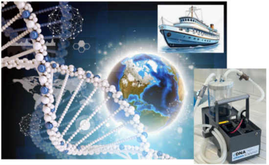
In collaboration with Swan Hellenic, the Cruising4Oceans RAISE Spoke TACS project designed and tested a framework to enable the collection and metagenomic analysis of microbial and environmental DNA along the global circumnavigation routes operated by SH cruises. DNA from surface ocean water (at a depth of 1m) is sampled at stations along the route using an innovative eDNA pump equipped with self-preserving filter units (0.45 μm), capable of filtering 10-15 liters of water in a few minutes and ensuring nucleic acid preservation at room temperature for up to 6 months. The project contributes to the creation of a Global Ocean Marine DNA Biobank with the potential to be updated over time.
The processing of the collected samples is provided by the University of Genova.
RAISE Spoke 3, within the framework of Project 11, has collaborated with TACS partner projects to strengthen the integration of advanced sensing technologies, citizen science, and data-driven environmental monitoring across both marine and urban contexts.
Two flagship initiatives (Cruising4Oceans and BAAS) exemplify this collaboration by transforming transport platforms into valuable scientific observatories.
Cruising4Oceans, launched by Swan Hellenic in August 2024, converts expedition cruise ships into active oceanographic research platforms. On board SH Vega and SH Diana, guests, crew and experts collect real-time marine data – including temperature, salinity and other metocean parameters – in remote regions such as the Arctic and Antarctic, where scientific observations are typically scarce. The initiative contributes high-quality data to research networks such as RAISE SPOKE3 and EMODnet, moving beyond impact mitigation to actively generate scientific value. Its strong citizen science dimension builds on collaborations with programmes including NASA cloud monitoring, Happywhale, the Secchi Disk Study and Antarctic seabird surveys. From 2025, the project will further expand through georeferenced biodiversity photography and the collection of environmental DNA (eDNA), enhancing large-scale monitoring of climate-driven ecosystem change.
BAAS (Bus As A Sensor) applies a similar approach in an urban setting by equipping electric buses in Genoa’s AMT fleet with sensors that monitor environmental conditions, passenger flows and onboard comfort during routine operations. These mobile sensing systems produce real-time, spatially distributed data – such as particulate matter concentrations – complementing fixed monitoring stations and supporting urban climate planning. A 2025 memorandum of understanding between AMT Genova and the RAISE ecosystem formalised collaboration to use the public transport fleet as a real-world experimental platform for robotics, AI and advanced data analytics. Originally developed to optimise transport services, BAAS now contributes to wider research on sustainability, accessibility and climate resilience.